DISTRICT BRIEF PROFILE
DISTRICT POLITICAL MAP
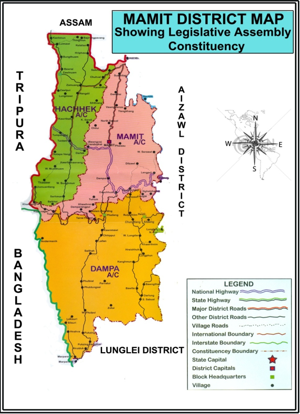
KEY STATISTICS
Population – 2011 | 86,364 |
Projected Population – (Current Year) | 1,33,813 |
Population Density | 29 per sq.km. |
Literacy Rate Total | 84.93% |
Literacy Rate Male | 89.13% |
Literacy Rate Female | 80.35% |
No. of Municipal Corporations | 0 |
No. of Municpalities | 0 |
No. of Blocks | 4 |
No. of Gram Panchayats | 89 |
No. of Revenue Villages | 89 |
Total Electors in District | 65,101 |
Male Electors | 32,310 |
Female Electors | 32,007 |
Third Gender Electors | 0 |
Sex Ratio – Projected Population | 991 |
Sex Ratio – (As per draft roll) | 983 |
EP Ratio – Projected Population | 480 |
EP Ratio - (As per final roll) | 481 |
No. of Parliamentary Constituencies (PC) | 1 |
No. of Polling Stations (PS) | 122 |
No. of Polling Station Locations | 118 |
No. of Assembly Constituencies (AC) | 3 |
No. of Returning Officers (RO) | 3 |
No. of AROs | 6 |
No. of Sector Officers (SO) | 15 |
No. of BLOs | 122 |
BRIEF NOTES ON MAMIT DISTRICT
About the District: Mamit District, carved out of the erstwhile Aizawl District in 1998, is situated in western region of Mizoram. It is located at a distance of 88 km from the State capital Aizawl.
The District is inhabited by Mizos, Brus and Chakmas. It is a landlocked District, with inter-state boundaries with Assam (45km) and Tripura (70 Km), and international boundary with Bangladesh (50 kms). The total geographical area of the District is 3025.75sq.km, with total population being 86,364 (2011 census). The District falls in the agro-climatic zone of Temperate Zone and is located between 92o17’E and 92o40’E, and 23o17’N and 24o15’N. The important rivers flowing through the District are Tlawng, Tut, Langkaih, Teirei, Khawthlangtuipui and Mar. There are 89 Village Councils in the District. Mamit is the principal town and headquarters of the District. Road is the predominant means of trade and travel.
Administrative setup: Mamit District is divided into three (3) Sub-Divisions, viz: West Phaileng Civil Sub-Division, Kawrthah Civil Sub-Division and Mamit Sadar Sub-Division. There are four Rural Development Blocks, namely Reiek RD Block, West Phaileng RD Block, Zawlnuam RD Block and Kawrtethawveng RD Block. The first office established in Mamit was Project Office which was opened in 1959 when Mizoram was one of the Districts under Assam. It was upgraded as Community Development Block Office in 1962. In 1978, Mamit was declared as a Civil Sub-Division Headquarters. Aizawl West District was created on 11.03.1998. The District was later renamed as Mamit District. Today, there are as many as 51 offices of different Departments under State/Central Government in Mamit Town.
Peculiarities in demography: There are three types of ethnic population like Brus, Chakmas and Mizos inhabiting the District.
Terrain: The entire District is covered by hilly terrain which is criss-crossed by valleys and deep gorges where the rivers wend their ways to constitute its river system. About three-fourths of the area of the District is drained by the north flowing rivers such as Tlawng, Tut, Teirei and Langkai whereas one-fourth of the District is drained by the South flowing rivers of Khawthlangtuipui and Mar rivers.
Specific socio-economic-cultural peculiarities relevant from election management point of view:
Inhabited by economically backward communities like Brus and Chakmas, the District is relatively backward than other Districts. The District lacks behind in a number of parameters especially in infrastructure and health sector and continues to be situated at the bottom of health parameters. Owing to this, the District was selected as one of the 117 Districts identified as Aspirational Districts by NITI Aayog.
Infrastructure availability: In terms of infrastructure availability, the District is well connected with State Highways (Major District roads, other District Roads, etc). The District Headquarters is connected by National Highway 44A. The nearest Airport is located at just a 2 hour’s drive. Mobile connectivity in the District is good, with various service providers active.
Places which are generally inaccessible or difficult to reach: There are a few places still inaccessible by road within the District, such as Dilzawl and Tlangkhang which have to be accessed by boat, and Bajirungpa, Chilui, Kananthar, Khanthuam, Stapa and Zopui which have to be accessed on foot.
Resource availability – manpower, logistics, IT related, etc: Majority of the State Government Departments have set up their Offices in the Headquarters, with some of the Departments having subordinate offices in Sub-Division and Block Headquarters. Necessary manpower therefore could be met by pooling /requisitioning office personnel from the Departments. Micro-Observers can be pooled from KVK, Lengpui, SIB Mamit and JNV Mamit. As per data available with District Transport Office, more than 240 LMV vehicles along with buses are registered in Mamit and vehicle requirement for Polling Parties and other election related officials could be met by hiring and requisitioning from government departments. Poor internet connectivity continues to remain a big challenge. However, different telecom and internet service providers work in the District, and there are no shadow areas in the District
General Law and Order situation: The overall law and order situation in Mamit District is by and large peaceful and no communal violence/tension has been reported in recent years. There was only one electoral offence in the last MLA Election, in which a total of Rs. 73,300 was seized by the Static Surveillance Team in 1-Hachhek Constituency. A District Level Committee to examine and decide upon seizure of cash under the Chairmanship of DEO decided that the seized cash was not linked to any illegal political/election activity. Accordingly, the seized cash was released by the concerned Returning Officer.
Mamit District shares about 50 kms of International boundary with Bangladesh and about 70 kms and 45 kms Inter-state boundaries with Tripura and Assam respectively. Polling Stations located along Indo-Bangladesh border and inter-state borders still remain vulnerable from the security point of view, even though no imminent security threat is perceived from any elements. The District is demographically heterogeneous but inter-tribal relationship among different communities - Brus, Chakmas and Mizos, Chin immigrants, etc. remains cordial.
Weather & periods of inaccessibility & places of inaccessibility: The District falls in the agro-climatic zone of Temperate Zone. The temperature ranges from 9°C to 24°C and 24°C to 35°C during winter and summer respectively. The District experiences monsoon during summer, receiving abundant rainfall and is neither too hot nor too cold throughout the year. Some villages are inaccessible during rainy season while villages like Bajirungpa, Dilzawl, Chilui, Kananthar, Khanthuam, Tlangkhang, Sotapa and Zopui are non-motorable at all.